Register now
The Michigan Department of Transportation (MDOT) will host an I-375 Reconnecting Communities Project Public Meeting on Tuesday, June 25, 20
block-detroitminew-views-block-news-events-block-1,News & Events*block-detroitminew-views-block-related-links-block-1,Related Links*block-detroitminew-views-block-video-playlist-block-1,Videos*documents-block,Documents*block-detroitminew-views-block-forms-block-1,Forms*block-views-block-faq-block-1,FAQs*block-detroitminew-views-block-district-map-block-1,District Map*block-views-block-council-office-directory-block-1,Office Directory*block-detroitminew-views-block-contacts-block-3,Contacts*block-detroitminew-views-block-contacts-block-4,Contacts*block-detroitminew-views-block-council-member-bio-block-1,Bio*block-detroitminew-views-block-sub-sections-block-1,Sections*block-detroitminew-views-block-web-apps-block-1,Web Apps*block-detroitminew-views-block-news-events-block-4,News*block-detroitminew-views-block-news-events-block-3-2,Events*block-detroitminew-views-block-contacts-special-block-1,Staff*block-detroitminew-views-block-statements-block-1,Statements*block-detroitminew-views-block-newsletters-block-1,Newsletters*block-detroitminew-views-block-newsletters-block-3,Ordinance*block-detroitminew-views-block-newsletters-block-2,Resolutions*block-detroitminew-views-block-newsletters-block-4,Memos
The City of Detroit hosted a community meeting on June 26th 2025 to get feedback on a zoning and land-use plan draft for the re-imagined I-375 corridor and boulevard. Attendees were given a presentation of the project’s context: Project Givens, Framework Overview, how the framework impacts the boulevard design, and what makes a Framework, and an overview of zoning and land-use. We recapped community meeting #2 and analysis – the scenario exercise where we asked attendees about their preferred land-use in the corridor, by parcel block.
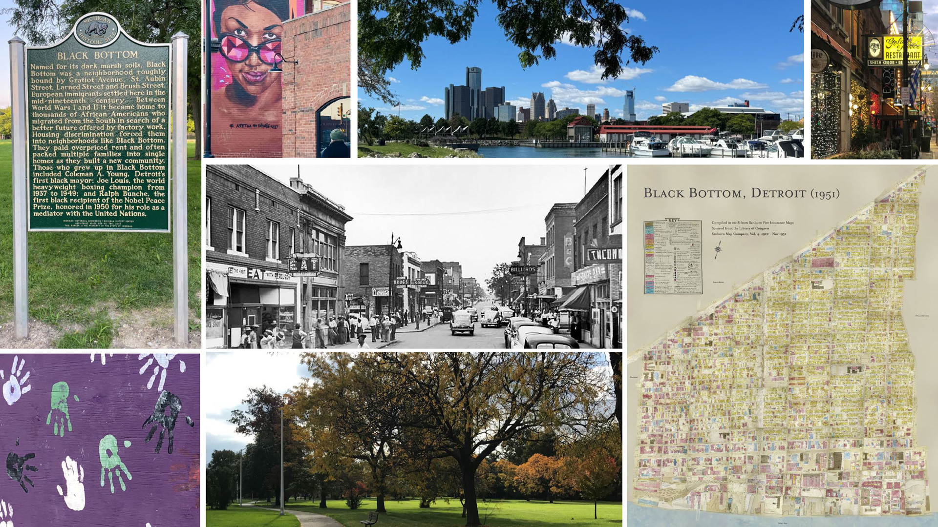
There was also an analysis of the underlaying land-use from the Master Plan of Policies to determine the general preferred land uses. The consultant team of Interboro Partners presented the draft plan. Additionally, the MDOT consultant team of Quinn Evans prepared an exhibit on the history of the project area centered bout the themes of Immigration + Integration, Black-Owned Businesses, Culture/ Arts/ Music, Impact of Urban Renewal, and Diversity of Religion. Attendees were asked to give feedback on businesses on Hastings Street in Historic Black Bottom and add comments or information we needed to know.
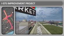
The I-375 Project by the Michigan Department of Transportation is a transformational project to convert the downtown interstate spur into a surface boulevard. The conversion will address inherent safety concerns in the design and maintenance of the highway and the bridges and accessibility into surrounding communities and the riverfront.
This project requires a greater understanding of the impacts to the surrounding communities: historic harm of past urban renewal efforts that removed a great center of black culture, commerce, and people; impacts of construction on surrounding communities and businesses and how to mitigate them; and the need to maintain safe connections and access for Detroiters and our visitors.
I-375 cut off the adjacent neighborhood from downtown and led to the demolition of Hastings Street, the last part of the Black Bottom neighborhood. Removing the expressway and replacing it with a boulevard will reconnect city streets in the area. While it won't bring back Hastings Street, it offers opportunities to honor the area's history, promote equitable development, enhance cultural spaces, and improve mobility.
The City of Detroit develop a Zoning and Land-Use recommendations from a study that is in support and part of the overall neighborhood framework from MDOT I-375 Project. The framework will have elements including urban design, open space, mobility, history arts and culture, in addition to zoning and land-use.
Since this is a major infrastructure project will have a substantial impact on nearby neighborhoods, a framework is needed.
The Zoning and land-use study will work to address the following:
The newly develop-able land will be owned by the State of Michigan and subject to Federal Department of Transportation regulations. Creating a plan with clear recommendations for the area is critical to help guide the future disposition of land and to direct financial resources for potential projects and enhancements.
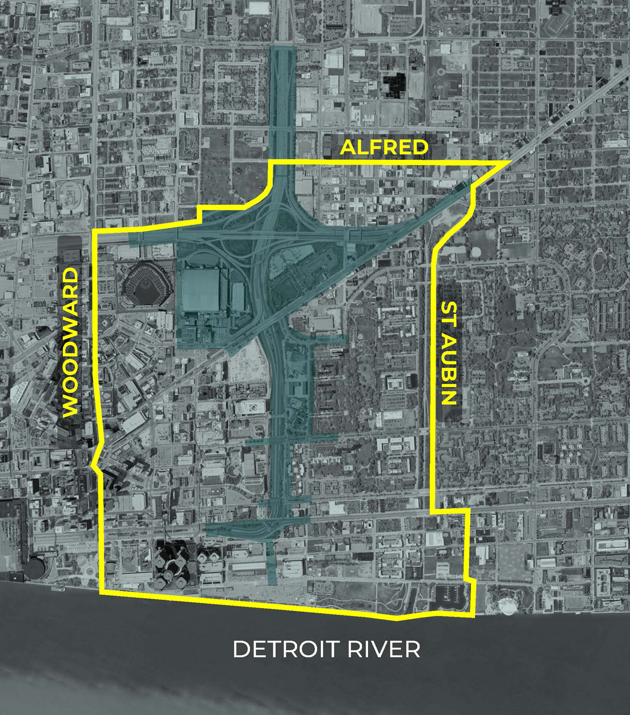
Zoning and Land-Use Boundary
MDOT has instituted a pause on the I-375 project to evaluate cost, design, and engagement in August 2025 . The city of Detroit has also paused on the zoning and land-use study; however has presented a draft plan in June 2025. When the project resumes, the time line will be updated to reflect the schedule. Feel free to review prior documents and meeting to get up to speed on the Zoning and Land-use study.
The City of Detroit hosted a community meeting to get feedback with a simple proposition – What can the creation of 30 acres of new land in the heart of our city do to improve the community? Attendees had a short thought exercise on scenarios developed from the perspective of the resident and from the visitor to Detroit to gather feedback on what given land uses could be used to improve the resident (residential) scenario and the visitor (Entertainment) scenario. Participants were then asked to create their own scenario through a longer, table exercise that did not have any preconditions using the given land-uses, other than existing landmarks. If participants wanted to add uses for consideration, they were given the opportunity to do so. We received a wide range of feedback, all of it important and all of it to be considered as we move forward in developing a zoning and land-use policy that is informed by Detroit residents.
Additionally, we introduced our new director of planning, Alexa Bush, who presented an overview of the framework and when the excess property comes online for future development; how the framework process can inform the future vision; an update on existing conditions; and a recap on Community Meeting #1.
The City of Detroit hosted a community meeting to introduce the I-375 Neighborhood Framework process and elements of study at The Eastern on December 3, 2024 at 5:30. There was a wonderful turnout where we got to listen to residents on their thoughts on the framework process and elements (such as zoning and land-use, urban design, and the role history art and culture should have in this project). Currently we are documenting the information from that meeting to make available for the public as well as the livestream from MDOT. Click here to view the PowerPoint presentation given during the community meeting.
The II-375 Reconnecting Communities Project is a transformative highway project converting I-375 and the Fisher HWY (Gratiot Connector) into a surface road; and using the residual parcels created for future development and open space. The surface boulevard replaces 3 outdated bridges spanning the highway and reconnects downtown to Lafayette Park and Eastern Market. The Michigan Department of Transportation, in partnership with the City of Detroit, will develop a framework on the highway, urban design and development, and opportunities centered on diversity, equity, and inclusion through an extensive community engagement process.
The project updates the poor condition of the current infrastructure, interchange design and outdated bridges. It accomodates all users for future transportation needs and roadway safety, improves vehicular and non-motorized connectivity to surrounding area and existing and planned transit services; and enhances access to future development and other placemaking opportunities.
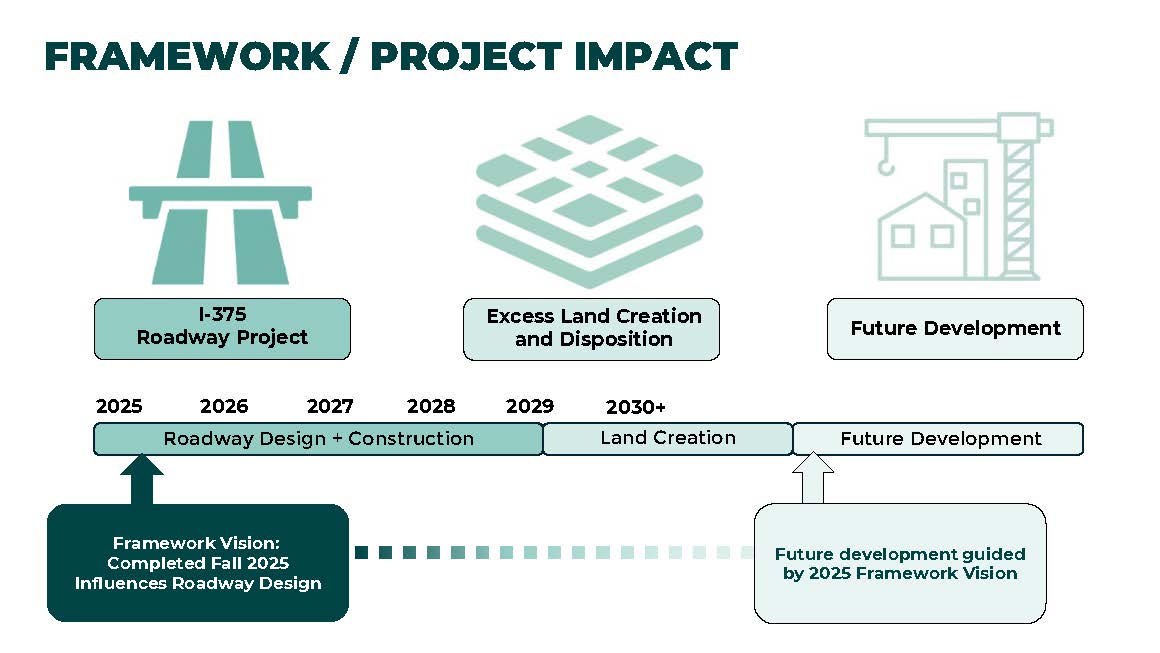
Pre-construction is expected in Q4 2025. Heavy Construction is from 2026-28.
The estimated construction cost of the project is $300 million with funding from federal and state sources.
No there is not a final design. There is a conceptual design based on the placement (location) and capacity of the new boulevard to handle current and future traffic.
From community feedback and safety concerns on the design, MDOT revisited traffic counts post pandemic and SEMCOG revised its growth estimate for the area to support a smaller boulevard width of 4 lines + two turning lanes.
The communities immediately adjacent to I-375 were engaged in community meetings open to the general public, community stakeholder meetings, and living room chats from 2017 up to 2020 at the start of the COVID-19 pandemic.
The focus of the conceptual design was more on geometry and physical impacts to the surrounding area. The framework will capture the historic narrative and individual stories to honor and celebrate the past and connect to the future through the engagement process regarding I-375 and the impact it had on the Black Bottom, Paradise Valley, and other communities in the cause of its construction.
The framework and engagment process will seek to responsibly address any construction impacts from I-375's construction to the extent we can. How we address any impacts will be in partnership with the federal government and State of Michigan.
That cannot be decided until the final design is completed and the disposition is determined to understand what will be available. Development will be encouraged to have diversity, equity, and inclusion as a core principle in how the area is developed - from ownership, to contracting, to use. Community enhancements will be determined with community involvement and input as well. Discussions are underway with the federal government as to how the land disposition takes place (transferring land within federal and state regulations). Nothing has been pre-planned; and no decisions will be made until the transfer is better understood.
In addition to the Planning Department's website, check out the link above to the MDOT website for information on future community engagement events for I-375 Reconnecting Communities Project as well as more detailed information on the project itself.
 https://www.youtube.com/watch?v=8XnR0NXvlvk
Announcement to Remove I-375 - September 2022
https://www.youtube.com/watch?v=8XnR0NXvlvk
Announcement to Remove I-375 - September 2022
 https://www.youtube.com/watch?v=XIzi_vtGW80
I-375 animation
https://www.youtube.com/watch?v=XIzi_vtGW80
I-375 animation
The Michigan Department of Transportation (MDOT) will host an I-375 Reconnecting Communities Project Public Meeting on Tuesday, June 25, 20
DETROIT, Mich.
Advocates say constructing highways through Black neighborhoo
If you missed the last I-375 Neighborhood Framework Community Meeting, come share your thoughts using the survey
Missed the last I-375 Neighborhood Framework Community Meeting? Come share your thoughts using the survey
Community Meeting #3 Digital Magazine June 26, 2025
June 22, 2025
Join us for the third community-wide meeting to recap discoveries from our second meeting, analysis and comments captured from community input on zoning and land-use
April 22, 2025
John Sivills
Lead Urban Designer (313) 224-4403