"The Get Out the Vote" Early Voting Block Party
July 25th 9am-5pm. Early Voting starts July 25th thru August 2nd. Click here for more information.

block-detroitminew-views-block-news-events-block-1,News & Events*block-detroitminew-views-block-related-links-block-1,Related Links*block-detroitminew-views-block-video-playlist-block-1,Videos*documents-block,Documents*block-detroitminew-views-block-forms-block-1,Forms*block-views-block-faq-block-1,FAQs*block-detroitminew-views-block-district-map-block-1,District Map*block-views-block-council-office-directory-block-1,Office Directory*block-detroitminew-views-block-contacts-block-3,Contacts*block-detroitminew-views-block-contacts-block-4,Contacts*block-detroitminew-views-block-council-member-bio-block-1,Bio*block-detroitminew-views-block-sub-sections-block-1,Sections*block-detroitminew-views-block-web-apps-block-1,Web Apps*block-detroitminew-views-block-news-events-block-4,News*block-detroitminew-views-block-news-events-block-3-2,Events*block-detroitminew-views-block-contacts-special-block-1,Staff*block-detroitminew-views-block-statements-block-1,Statements*block-detroitminew-views-block-newsletters-block-1,Newsletters*block-detroitminew-views-block-newsletters-block-3,Ordinance*block-detroitminew-views-block-newsletters-block-2,Resolutions*block-detroitminew-views-block-newsletters-block-4,Memos
As Detroit’s oldest neighborhood, the history of Corktown speaks for itself
The City of Detroit launched the Greater Corktown Planning Framework Study in spring 2019. The Planning Framework study is an initiative that engages residents in creating a plan that promotes inclusive growth of Detroit’s oldest established neighborhood while preserving the community’s unique character, cultural heritage and integrity.
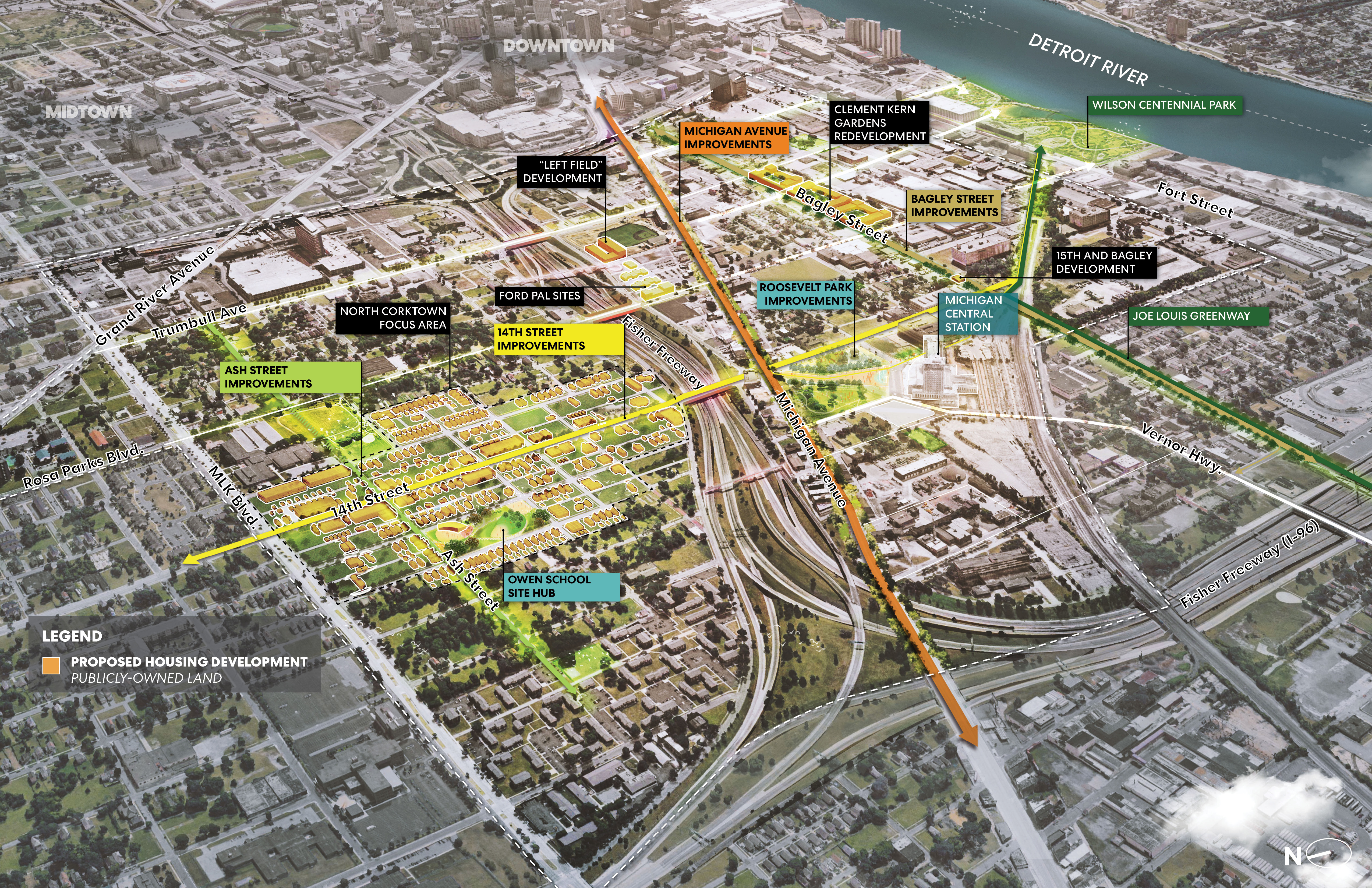
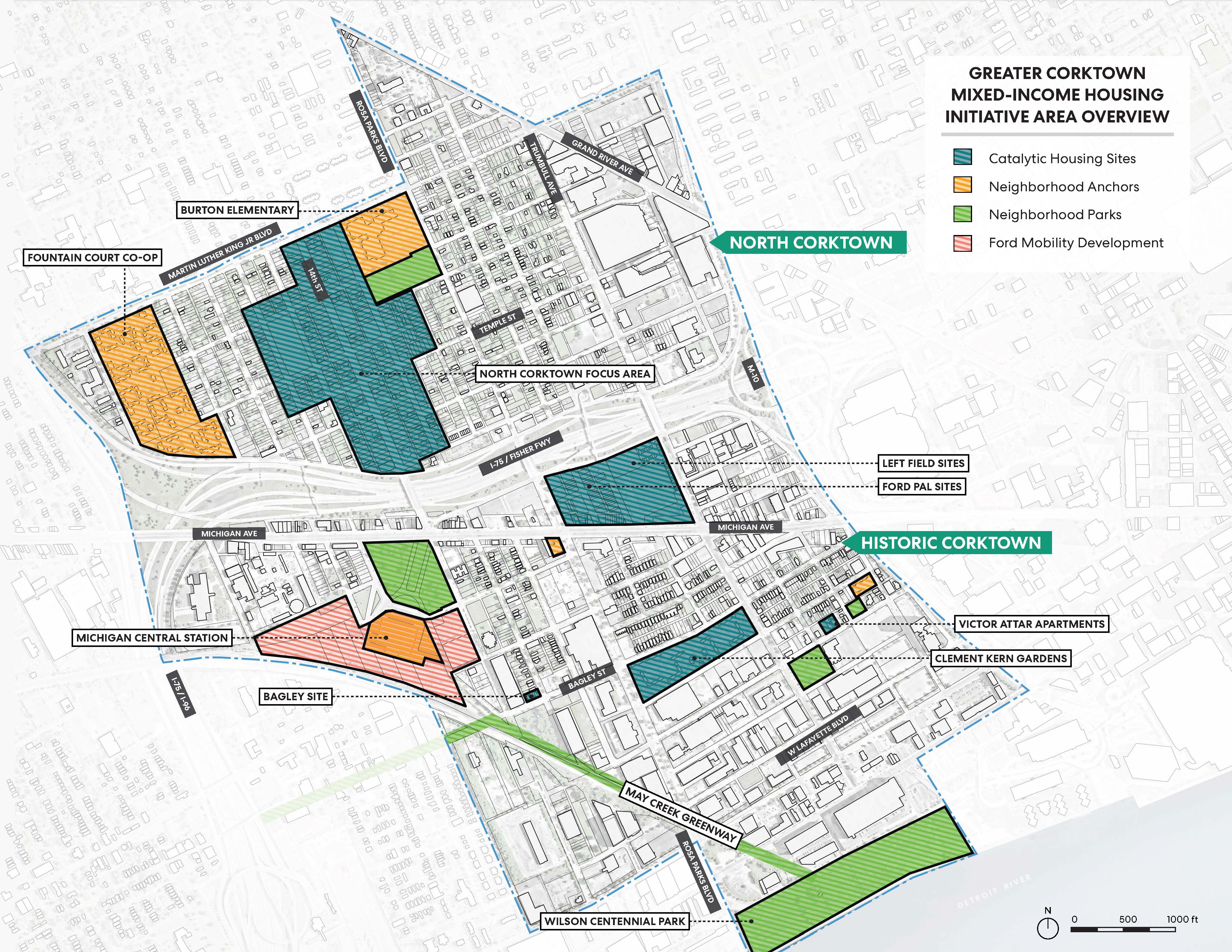
Greater Corktown, or “The Study Area,” is the name of the planning study area, primarily comprised of North Corktown and Historic Corktown neighborhoods with a portion of Core City and Hubbard Richard neighborhoods as well. For the past year, the planning team has been engaging with residents, identifying challenges and opportunities, and developing practical strategies around:
• Urban design and landscape;
• Development and zoning;
• Streetscapes and connectivity;
• Improved pedestrian experience;
• Historic preservation; and
• Housing development and rehabilitation.
This plan casts a wide net of strategies to help guide the Study Area forward. As you read the plan, you will notice several key takeaways framing the recommendations:
Ensure zero residential displacement occurs.
There is an ample amount of vacant land (both publicly and privately owned) that presents an opportunity for both development and preservation
Maintaining and advancing housing affordability is a key driver of the development objectives
Streets offer improved connectivity—for vehicles, pedestrians, bicyclist—by improving roadway design, extending sidewalks
Building off of catalysts and existing investments including the Ford Land investments in Michigan Central Station and adjacent real estate, the Police Athletic League Ballpark, the May Creek Greenway project (part of the Joe Louis Greenway), and (even though it is not in the Study Area) the nearby planned Wilson Centennial Park.
Addressing the funding realities through partnership and collaboration amongst public, private, non-profit, and philanthropic entities utilizing this plan as a shared vision for the future.
Project Manager:
Kevin Schronce
Design Director (313) 224.9489 [email protected]Join us for the Greater Corktown Choice Neighborhoods Street Improvement Community Meeting on May 21st, 5:00 PM
Below is an index of public meeting summaries, documents, and engagement materials
*There were other “informal” meetings held throughout the Greater Corktown study area either by zoom or phone with along with canvassing efforts
Public Meetings
Pop Up Meetings
Bi-Weekly Newsletter
The City of Detroit and the Detroit Land Bank Authority are moving forward in partnership on a Greater Corktown housing strategy, which could result in the creation of more affordable housing units located across the Historic and North Corktown neighborhoods. After significant dialogue with the community over the past year through the Greater Corktown planning framework process and MI Central Station Community Benefits process, concerns around preservation of existing and construction of new affordable housing units within Corktown have constantly risen to the forefront.
These conversations as well as a series of very successful community meetings in early 2020, have resulted in the City’s Planning & Development and Housing & Revitalization Departments to work towards applying for a Choice Neighborhoods Implementation (CNI) grant by this coming summer 2020.
Corktown Parking Study Public Presentation
September 2022
North Corktown Zoning Update Presentation shown to North Corktown residents on April 19th, 2021
Zoning comparison chart that highlights the proposed zoning changes for the North Corktown neighborhood
Presentation shown at the Greater Corktown Framework: Implementation Projects Community Update Meeting held on April 13th, 2020
Supplemental Information Includes: Historic Preservation Report; Detailed Parking Strategy; Economic Incentives Detailed Assessment; and Business and Retail Detailed Strategy
Kevin Schronce
Design Director (313) 224.9489 [email protected]Information on Michigan Avenue Planning & Environmental Linkages (PEL) Study