"The Get Out the Vote" Early Voting Block Party
July 25th 9am-5pm. Early Voting starts July 25th thru August 2nd. Click here for more information.
block-detroitminew-views-block-news-events-block-1,News & Events*block-detroitminew-views-block-related-links-block-1,Related Links*block-detroitminew-views-block-video-playlist-block-1,Videos*documents-block,Documents*block-detroitminew-views-block-forms-block-1,Forms*block-views-block-faq-block-1,FAQs*block-detroitminew-views-block-district-map-block-1,District Map*block-views-block-council-office-directory-block-1,Office Directory*block-detroitminew-views-block-contacts-block-3,Contacts*block-detroitminew-views-block-contacts-block-4,Contacts*block-detroitminew-views-block-council-member-bio-block-1,Bio*block-detroitminew-views-block-sub-sections-block-1,Sections*block-detroitminew-views-block-web-apps-block-1,Web Apps*block-detroitminew-views-block-news-events-block-4,News*block-detroitminew-views-block-news-events-block-3-2,Events*block-detroitminew-views-block-contacts-special-block-1,Staff*block-detroitminew-views-block-statements-block-1,Statements*block-detroitminew-views-block-newsletters-block-1,Newsletters*block-detroitminew-views-block-newsletters-block-3,Ordinance*block-detroitminew-views-block-newsletters-block-2,Resolutions*block-detroitminew-views-block-newsletters-block-4,Memos
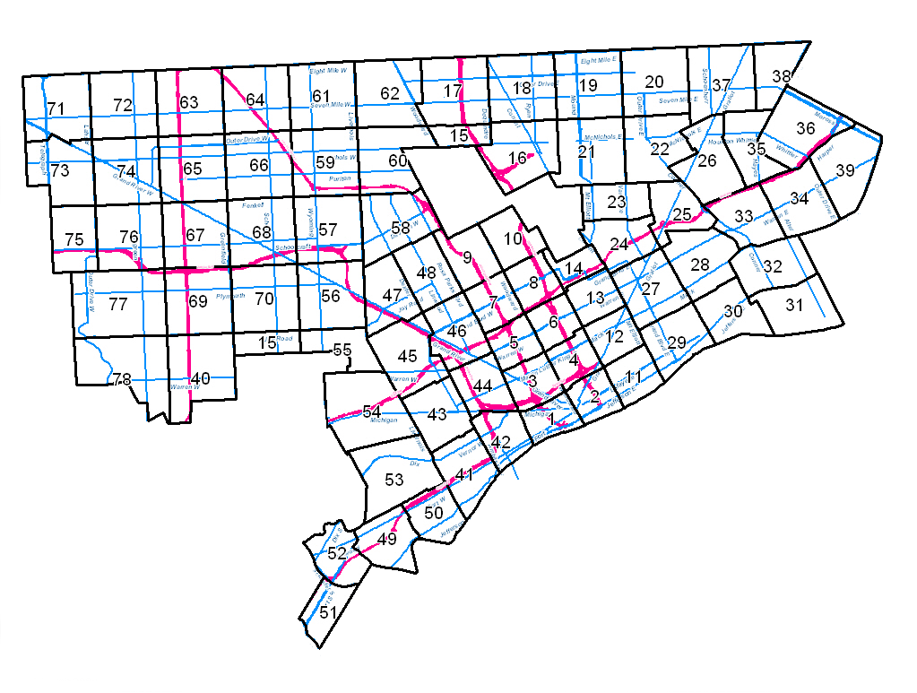
To see zoning detail for any portion of the City, click on the map below:
In this index map, the heavy black lines form the boundaries to the zoning maps, the red lines are freeways, and blue lines are major streets.
In the individual zoning maps, local historic districts are shaded with dots, areas designated as "urban renewal" are outlined in heavy dashed lines, and areas subject to design review are outlined in pink. Zone Map Index Meaning
Individual Zone Map 69
Individual Zone Map 18
Individual Zone Map 17
Individual Zoning Map 56
Individual Zoning Map 73
Individual zoning Map 76
BSEED/Development Resource Center (DRC)
(313) 224-2372 Coleman A Young Municipal Center 4th Floor, Ste. 434, 2 Woodward Avenue, Detroit, MI 48226 (313) 224-2372 [email protected]Buildings Safety Engineering and Environmental (BSEED)
Construction Division
Construction Inspection Division
Development Resource Center
Environmental Affairs Division
[email protected]Jayda Philson
Manager of BSEED Zoning Division (313) 224-1317 [email protected]License & Permits Division
Property Maintenance
Zoning/Special Land Use Division