Detroit Street View
block-detroitminew-views-block-news-events-block-1,News & Events*block-detroitminew-views-block-related-links-block-1,Related Links*block-detroitminew-views-block-video-playlist-block-1,Videos*documents-block,Documents*block-detroitminew-views-block-forms-block-1,Forms*block-views-block-faq-block-1,FAQs*block-detroitminew-views-block-district-map-block-1,District Map*block-views-block-council-office-directory-block-1,Office Directory*block-detroitminew-views-block-contacts-block-3,Contacts*block-detroitminew-views-block-contacts-block-4,Contacts*block-detroitminew-views-block-council-member-bio-block-1,Bio*block-detroitminew-views-block-sub-sections-block-1,Sections*block-detroitminew-views-block-web-apps-block-1,Web Apps*block-detroitminew-views-block-news-events-block-4,News*block-detroitminew-views-block-news-events-block-3-2,Events*block-detroitminew-views-block-contacts-special-block-1,Staff*block-detroitminew-views-block-statements-block-1,Statements*block-detroitminew-views-block-newsletters-block-1,Newsletters*block-detroitminew-views-block-newsletters-block-3,Ordinance*block-detroitminew-views-block-newsletters-block-2,Resolutions*block-detroitminew-views-block-newsletters-block-4,Memos
Mapping our city street by street
About
Detroit Street View (DSV) is a remote sensing program run by the Enterprise Geographic Information Systems (EGIS) Team within the Department of Innovation and Technology. The mission of Detroit Street View is “To continuously observe and document Detroit’s changing physical environment through remote sensing, resulting in freely available foundational data that empowers effective city operations, informed decision making, awareness, and innovation.”
History
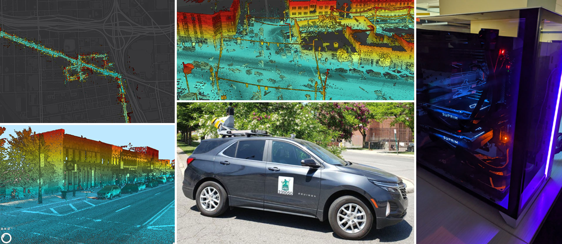
DSV started in 2017 with capturing single-frame GoPro imagery along commercial corridors. The program was awarded a Mayor’s Innovation Grant in 2018, and expanded to include 360° panoramic imagery, terrestrial LiDAR, and eventually two full-time drivers. A generous grant from General Motors in 2022/2023 funded the purchase of upgraded camera and LiDAR equipment as well as a new vehicle.
Philosophy and Value Proposition
The Detroit Street View program is based on a “Map Everything” philosophy. The program’s mobile mapping technology captures panoramic imagery (photographs looking in all directions) and LiDAR point clouds (3D models) of the visible world from a perspective shared by everyone – on the street. DSV realizes economies of scale and observational consistency for city operations by reducing the need for third party data purchases and minimizing the necessity of multiple visits to the same place to observe and collect data. For example, separate trips or data purchases may not be required to complete a blight assessment, traffic sign inventory, address investigation, and topographic survey all on the same block. Given comprehensive shared observational data, a wide variety of insights and foundational geospatial data can be derived, increasingly empowered by emerging machine learning and computer vision technologies. Repetitive collection additionally enables time-based insights like before-and-after analysis and change detection. Significant innovative opportunity exists to develop new ways to extract/analyze data and create value for a wide variety of applications.
Outreach
Central to the Detroit Street View program is a core value of openness…that ‘Data should be appropriately transparent, available, and usable for employees, partners, and the public.’ Collected data is made available for public use while particular care is taken to preserve personal privacy through anonymization of images (blurring of faces and license plates). Additionally, Detroit Street View values educational opportunities for Detroiters and partnerships with external organizations that lead to further data development and innovation.
Please send inquiries about the Detroit Street View program to [email protected].
Data
- Open Data Portal: Imagery
- Open Data Portal: LiDAR Index
Report an inappropriate image on Detroit Street View